Google usually takes the spotlight when it comes to maps. However today Microsoft is giving them a run for their money, or at least trying to stay relevant in the “maps” space.
Early today Microsoft released a new Bing Maps Beta, live for public use. This update packs in features they hope will captivate users. However excited you may be before you jump in, you will need to make sure your browser supports Microsoft Silverlight as this new Microsoft flash competitor is what drives the new Maps app.
First Thoughts
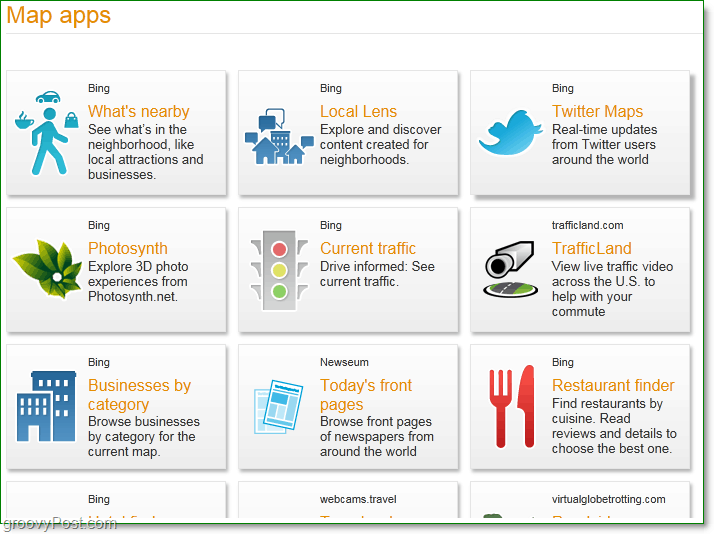
Bing Maps has a new welcome page bar; now you’ll be greeted by local weather information, local photos, and local Photosynths. Clicking the See More Apps button from the application bar will bring up a huge list of new map applications that Bing has introduced
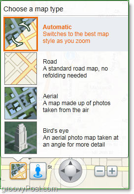
Overall the Bing Maps Beta provides four different options for browsing maps including the Automatic feature which chooses the best map for your level of zoom. The Bird’s Eye map is one of my favorites, which so far is not available in Google Maps.
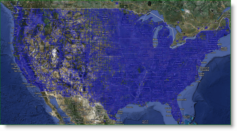
Next up on the navigation panel is the Streetside mode, Microsoft’s answer to Google’s Streetview. After exploring the streets, it would appear Microsoft has a better picture quality that its competitor and again, leveraging Silverlight, the scrolling and zoom is also much smoother on the mini-map. There were some glitches on performance while traveling down the road as many of the Polygons generated from the 3d imagery took extra time to load. We’ll see if this gets fixed after the beta. If you happen to see people walking down the sidewalk as you explore Streetside view, you’ll notice their faces are all blurred. Microsoft has done this to protect privacy just as Google Maps has already implemented. The downside to Bing Streetside mode – it doesn’t have near the imagery of Google StreetView. If you’re curious just where all Microsoft has mapped, click the street mode button and look for the blue outlines. Google Maps U.S. StreetView Coverage In Blue
Bing Maps StreetSide Coverage In Blue
From a coverage standpoint, yeah, there’s no comparison (not to mention BING Maps StreetSide is U.S. only at the moment.) Another groovy feature found in the aerial view (Look for the green markers) is the integration of Bing Maps and Microsoft Photosynth.
Photosynth is a technology introduced by Microsoft that allows users to collaborate multiple angled photos from a single event to create their own off-street view. The rotation of the image will depend on the number of pictures and angles taken by users, but the recognition software will allow you to rotate around an image. It’s not exactly Streetside view, but it doesn’t require a mobile camera vehicle either. Honestly, it’s one of the grooviest things Microsoft has done in a long time. I’m excited they’ve integrated it into their Maps software!
Heard enough? Go try out the new Bing Maps for yourself! We’d love to hear any comments or questions you might have either below or in the groovy community. You want to know what drives me crazy about Silverlight? It doesn’t run on a 64-bit version of IE.. https://www.groovypost.com/forum/download/file.p… nice… Also- the comparison between Google and Bing on the street view.. well… obviously Google should have more % covered as it’s been offered for years.. while Bing has only just started offering it. Anyway, I can only guess that we should expect to see another car with a camera on it’s room traveling the roads of the world as Microsoft builds up it’s StreetSide imagery. As Microsoft does this, I hope they use something like a Canon 40D / 5D as this is their chance. Don’t take 300k .JPG file, make the images stand out with 5 Meg .JPG files!! ;) They are using their PhotoSynth technology to populate the images. I’m not sure if you have ever seen it, but it is pretty amazing. They take user uploaded photos, and “synth”esize them together to get the 3D image. So, as people upload images, their catalog will become bigger. If it catches on, it has the chance to become bigger and become bigger faster than Google since there are a lot more people uploaded photos of places than their are Google image cars roaming around. I like MS Maps for Birds Eye, but that’s about it. I find StreetView to be much more useful for real life situations, however, since I’m driving to new places on street level instead of an airplane. Take a look here: http://bit.ly/7I0QKs – It’s a shot from my home town (SF). If you look East you will notice a White SUV following you. Travel East or west and you will see the same car stays with you. Anyway, I “love” photosynth! It’s truly amazing! I’m really glad to see BING MAPS is making it easier to see them by integrating them into the map. Really cool stuff! Checkout this one: http://bit.ly/6eyMQ5 aka “The Rock”. Very cool stuff baby yeah! Yeah, unless Microsoft is able to pull and create photosynths from an image repository somewhere (buy flickr???) they won’t be able to compete with google picasa web. Picasa web has millions (billions???) of photos to apply to their maps! lol – funny. I’m running 64-bit Windows 7 client and had no idea I even has a 64-bit version of IE. All this time the default is to use the 32-bit version. Funny….. why should I use the 64-bit version anyway? I’ve never seen “The Rock” photosynth before.. that’s pretty awesome, thanks for the link. As for “Microsoft stealing things”.. well I won’t be the judge of that, but Google definately doesn’t steal things.. but they sure do buy the companies that make their most used products (except for search of course). I think your right also. Microsoft is using photosynth technology to stitch together the photos once the car shoots them. Sweet stuff. My only wish is that Photosynth allowed more than just 1 gigs of photos on the personal upload photosynth.net site. oh well… Comment Name * Email *
Δ Save my name and email and send me emails as new comments are made to this post.


